There are many sources that say it's on average 2 percent.
I had long assumed this was correct, it turns it out that it's complete rubbish, and it's actually about one-tenth of that.
Here is a good overview, which says:
... if all of the water in the atmosphere rained down at once, it would only cover the globe to a depth of 2.5 centimeters, about 1 inch.
This number seems to be widely accepted and seems very plausible, although some say as much as 1.5 inches.
The total mass of air pressing down on 1 m2 of Earth's surface is about ten tonnes, a 2.5cm deep x 1 m2 puddle = 25 litres = 25 kg of water. So that means about 0.25 per cent by mass, or about 4,000 ppm by number of molecules, about ten times as much as there is CO2.
------------------------------------------
The lapse rate and latent heat of evaporation.
We know that the dry lapse rate should be about 10 degrees/km, that's easy, it's acceleration due to gravity ÷ specific heat capacity = 10 degrees/km. Energy is conserved, it just changes from one form to another; thermal energy is converted to potential energy when air rises and vice versa. But the observed lapse rate is only 6.5 degrees/km. So there are 3.5 degrees/km 'missing'. How does that tie in with the amount of water vapour, which holds 2,257 J/g of latent heat?.
I spent about two hours scribbling calculations to reconcile all this before I noticed that the original estimate is out by a factor of ten; after that it took five minutes. The answer is about 9 grams of water per m3 at sea level, falling by 1.5 grams per m3 per kilometre altitude up to 6 km altitude. The air is pretty dry above that (all water vapour has condensed out as clouds). Add them all up, and you get back to the total mass of about 2.5 kg in the lowest 6 km (average = 4.5g x 6,000m = 2.7 kg).
Entropy says the total amount of energy will spread out evenly. Using rounded figures...
1 m3 at sea level has:
- potential energy = 0 kJ
- 288K x 1,000 J/K/kg thermal energy = 288 kJ
- 9g water vapour x 2,257 J/g latent heat = 20 kJ
Total 308 kJ.
1 m3 at 1 km altitude has:
- 1 kg x 9.81 N/s2 x 1,000m = 10 kJ potential energy
- 281.5K x 1,000 J/K/kg thermal energy = 281 kJ
- 7.5g water vapour x 2,257 J/g latent heat = 17 kJ
Total = 308 kJ = the same as at sea level.
Reality check: 9 grams/m3 = 7g/kg of air = 65% relative humidity at 288K. That seems a bit high, but that is probably largely due to my crass rounding, approximations and the fact that sea level temps are between 'below freezing' and 'very warm' and RH is not linear with temperature. Above the Poles at minus 20C and 50% RH, there's only 0.6g/kg; over the tropical oceans at 30C and 75% RH, there's 20 g/kg. Or something like that.
------------------------------------------
Then there's the thorny issue of splitting that 2.5kg into gaseous water vapour and tiny droplets in clouds (which have lost their latent heat). It turns out that the amount actually in clouds is only a few grams out of the 2.5 kg total, so can be ignored for these purposes.
------------------------------------------
Which is all rather surprising really; of all the water on Earth, only about 1/10 of 1% of 1% is in the atmosphere, and only a small fraction of that is in clouds. Yet clouds they have a dramatic effect on the weather, and if you overlook them, your in/out radiation calculations will be wildly wrong. For some reason, AGW Theories rely on the wildly wrong calculations, but hey.
Saturday, 18 June 2022
1. What percent of the atmosphere is water vapour? 2. The lapse rate and latent heat of evaporation
Posted by
Mark Wadsworth
at
10:28
5
comments
Saturday, 9 April 2022
Dear Climate Scientists - do clouds exist or not?
From NASA's Clouds and radiation factsheet:
The study of clouds, where they occur, and their characteristics, play a key role in the understanding of climate change.
Clouds exist. Before we worry about marginal changes, it's good to understand how clouds anchor sea level air temperature at average 288K.
The Earth's climate system constantly adjusts in a way that tends toward maintaining a balance between the energy that reaches the Earth from the sun and the energy that goes from Earth back out to space.
Correct and agreed.
Energy goes back to space from the Earth system in two ways: reflection and emission.
Part of the solar energy that comes to Earth is reflected back out to space in the same, short wavelengths in which it came to Earth. The fraction of solar energy that is reflected back to space is called the albedo. Different parts of the Earth have different albedos. For example, ocean surfaces and rain forests have low albedos, which means that they reflect only a small portion of the sun's energy. Deserts, ice, and clouds, however, have high albedos; they reflect a large portion of the sun's energy.
Over the whole surface of the Earth, about 30 percent of incoming solar energy is reflected back to space.
So clouds exist for the purpose of calculating albedo and are considered part of the surface. They said it themselves. Good. The 30% reflected is the weighted average of the two-thirds of the surface covered by clouds with albedo 40% and one third cloud-free oceans/land with albedo 10%. This leaves an average of 238 W/m2 being absorbed by clouds and cloud-free ocean/land. All coherent so far.
The top of the cloud is usually colder than the Earth's surface. Hence, if a cloud is introduced into a previously clear sky, the cold cloud top will reduce the longwave emission to space, and (disregarding the cloud albedo forcing for the moment) energy will be trapped beneath the cloud top. This trapped energy will increase the temperature of the Earth's surface and atmosphere until the longwave emission to space once again balances the incoming absorbed shortwave radiation.
Clouds still exist. The conclusion is broadly correct, but the explanation is poor or downright misleading. Clouds are emitting what LW they can. The upper layers that emit to space are average 255K (sea level temp 288K minus 5km altitude x 6.5 K/km lapse rate) and, given their emissivity of 70%, emit 168 W/m2. Note that the word or concept "emissivity" is not mentioned in the article. As they say themselves, there is a separate system that operates as between clouds and sea level; what we are looking at is the 238 W/m2 from the Sun and back out to Space.
So for every three square metres of Earth (two of clouds, one of cloud-free) total outgoing LW has to be 3 x 238 W/m2 = 714 W total. The two m2 covered by clouds are emitting 2 x 168 W = 336 W/m2. That means the remaining 1 m2 of cloud-free oceans/land has to be emitting 714 - 336 = 378 W.
[Analogy: it's like inflating an air matress with a puncture. Cloud-free areas are the puncture. The smaller the puncture a) the higher the air pressure in the mattress and b) the faster the air will leak through the puncture.]
Ocean/land emissivity is 96%, so working backwards from 378 W/m2, the temperature of ocean/land has to be 288K to bring up the overall average LW emitted to space of 238 W/m2. 168 + 168 + 378 = 714. The upwards LW absorbed by clouds and LW reflected or re-emitted down again by clouds need not be taken into account again - we have an answer that ties in with actual observed temperatures and the gravity-induced lapse rate of 6.5 K/km (assuming average cloud-top altitude to be 5km, which seems about right). The reflected and re-emitted LW is already part of that overall balance.
And now, having shown that the entire Greenhouse Effect can be attributed to clouds (once you factor in emissivity, which Climate Scientists seldom do), clouds leave the stage and The Villain makes a surprise entrance:
However, a significant fraction of the longwave radiation emitted by the surface is absorbed by trace gases in the air. This heats the air and causes it to radiate energy both out to space and back toward the Earth's surface.
So, let's ascribe the effect of clouds to 'trace gases', shall we? Ignore the big white fluffy things that cover two thirds of the surface and reflect and absorb significant amounts or radiation in both directions and provably cause the entire Greenhouse Effect? Let's focus on invisible trace gases?
To ram the deception home, they conclude with this:
The overall effect of all clouds together is that the Earth's surface is cooler than it would be if the atmosphere had no clouds.
That is quite simply untrue, they've provided all the evidence to show that clouds have - surprisingly perhaps - a warming effect at sea level. See the calculation a few paragraphs above. Which is why the Greenhouse Effect is much smaller in cloud-free deserts, non-existent on Mars (a few scattered dust clouds) and very high on Venus (100% covered in very thick, very high clouds). But let's not drag real life into this, eh? Let's live in our logic-free fantasty world?
Conclusion: the Climate Science argument is there is a 33 degree Greenhouse Effect (sort of true) and that this is down to 'trace gases'. Therefore, more trace gases = more Greenhouse Effect. But the Greenhouse Effect is actually a measurement problem - on closer inspection either there isn't one at all and/or it is down to clouds. Therefore trace gases have zero impact, therefore any change in trace gas levels can't have any effect either. I have no strong opinion on what causes small fluctiatons in surface temperatures over longer periods, but it sure as heck ain't changes in the amount of trace gases.
Posted by
Mark Wadsworth
at
13:17
2
comments
Monday, 13 September 2021
Why are clouds at that particular altitude?
If you round up two-thirds cloud cover to 100% cloud cover and assume they have an albedo of 0.3, then the real reason for the apparent 33 degree Greenhouse Effect is immediately obvious, as I explained a month ago.
The next question to be answered is, why do clouds form so that the average altitude of their upper surface (the surface which absorbs and is warmed by solar radiation) is at about 5 km* (with a resulting sea level temperature of 288K)? Why not 4 km or 10 km? I've struggled with this for the past month, and, much head scratching, calculating, sketching and Bingling later, what it boils down to is as follows:
* Clearly, cloud cover is not 100% at 5 km and clouds don't have an alebdo of 0.3. Cloud cover is about two-thirds; their upper surface is higher than 5 km (call it 7 km); and clouds have an albedo of 0.4. But if you do a weighted average altitude and albedo of 'what the sunshine hits first' it's 5 km and 0.3.
1. The dew point of the water vapour in any 'parcel' of air depends on three variables. For a start let's focus on i. air temperature and ii. air density/pressure. We'll get back to variable iii. Relative Humidity later, You can merge ii. and iii. into one variable called 'partial water vapour pressure', but it's easier to treat them separately:
For a given R.H., in warm air, water vapour is likely to stay as a gas; in cold air it is more likely to condense and fall as rain. There's a narrow range of temperatures where it remains as tiny droplets which remain suspended in the air:
2. For a given R.H., if air has low pressure/density, the water vapour is more likely to remain as vapour. If it's high pressure/density, it is more likely to condense and fall as rain:
3. We can put those two together into a table of all possible temperature/pressure combinations.
Some vapour in the air will condense into tiny droplets, small enough to stay suspended and form clouds. Only those clouds which happen to form at the altitude where that particular temperature-pressure combination is in the white band will remain as clouds. So they could be low and warm or cold and high:
4. But the upper surfaces of clouds tend towards the same temperature because they absorb solar radiation. With an albedo of 0.3, they will reach an average temperature of 255K (average of day and night). So they mainly form at the altitude where the pressure/density is such that they fall into the white 'just right' band. Any higher, they will evaporate again, any lower and they will condense and fall as rain:
5. OK, so some clouds have formed at the 'right' altitude and are stable for now. We know the temperature of their upper surface, and that that temperature plus altitude x lapse rate (also known) determines sea level temperature.
But wouldn't this be positive feedback? Higher clouds = warmer surface = overall warmer atmosphere = atmosphere expands verrtically = higher clouds? For example, the whole tropsphere over the Equator and Tropics is twice as high as over the Poles, with a correspondingly higher 'right' cloud altitude.
What sets the upper limit..?
6. The upper limit is set by the third main factor for determining dew point - Relative Humidity. It is chaotic and dynamic but self-correcting. If the clouds are too high, so is sea level temperature, which leads to more evaporation, higher R.H. and higher R.H. means lower clouds again, and vice versa:
7. Some clouds will form at the 'Goldilocks' altitude where the resulting sea level temperature generates enough R.H. to maintain the clouds at that particular altitude. This is arrived at by trial and error, and while the precise calculations are beyond human comprehension, clouds do it for us by simply following basic laws of physics until they 'get it right':
8. Finally, you end up with what you expect to see. Sea level temperature 288K; clear air up to a certain altitude (too warm for clouds to form); a layer of clouds 1 or 2 km thick (the 'Goldilocks altitude'); above that clear air again (the pressure/density is so low that clouds evaporate again). Clearly, this is weather, so these are not exact values. They are all constantly overshooting in both directions, but it all oscillates around some sort of equilibrium and averages out.
9. What other evidence to we have to support this, apart from it matching up to observations and being entirely consistent with basic physics and everything else in the overall theory?
a. All I can think of for now is that areas with higher R.H. tend to have lower clouds (as you would expect. If there's more water vapour it's more likely to condense at a lower altitude) and their sea level temperature tends to be a bit lower (lower cloud altitude means the difference in temperature between upper surface of clouds and sea level is lower, as there are fewer km to multiply by lapse rate) than in drier areas.
b. Higher R.H. and lower clouds also mean a much smaller day-night ('diurnal') temperature range - water vapour is good at holding on to thermal energy and the lower clouds are good at reflecting upwelling IR back down to sea level in the night time. This is also observed in real life.
c. Venus and Mars follow exactly the same pattern, even though their atmospheres are nearly 100% CO2 and other 'greenhouse gases'.
Posted by
Mark Wadsworth
at
16:40
3
comments
Labels: Clouds, greenhouse effect, Physics, Science
Friday, 13 August 2021
An inconvenient truth
I have spent the last year and a half reading up on AGW theory. One after another, I have managed to iron out most of the contradictions, half-truths and flawed explanations for correct observations. Each one is a bit of an intellectual effort to overcome because it's all things that most people - Alarmists, sceptics, weather forecasters and the man in the street (i.e. me) - just take for granted.
I have spent most of that year and a half kicking myself for being sent off in the wrong direction for not having noticed something sooner, going back, rethinking and redoing my workings (and regretting many of my posts based on false - but widely held - assumptions). I hope that I have now got the bottom of it all and overcome the final false assumption, which had been nagging me for months...
----------------------------------------
The 'inconvenient truth' is that the entire Greenhouse Effect is due to clouds (and their altitude)!
All the Alarmist pictures and diagrams just show the sunlight hitting the surface and being reflected back down by Greenhouse Gases. Clouds - when they appear at all - merely serve to reflect even more radiation back down and 'warm' (i.e. slow down the cooling of) the surface (which they clearly do during the night time).
To get back to reality, you have to draw in the cloud cover (accepted as two-thirds of the surface, so we might as well round that up to 'all of it') on all their pictures and diagrams and realise that most sunlight hits clouds first - that is the layer that absorbs sunlight. The temperature of their upper surface is determined by sunlight, and that in turn dictates the temperature of land and oceans via the gravito-thermal effect (the Greenhouse Effect = cloud altitude x lapse rate).
When you draw in the missing clouds, you realise what's causing the 'back radiation' and what's blocking terrestrial radiation from all getting to space and being measured by satellites. They are big white things that can be miles thick. They reflect sunlight, so we have to assume they reflect all EM radiation to the same extent (arguably more). It appears to be widely accepted that higher clouds mean a warmer surface than lower clouds, this is a correct observation and ties in with all this.
Another smoking gun is that on Venus and Earth, the upper surface of clouds is at the 'average emitting altitude' aka 'effective radiating layer'. This is not a coincidence - to all intents and purposes, they are the 'effective radiating layer'.
Clouds are also the 'effective absorbing layer' as far as incoming sunlight is concerned. Remember that they calculate a planet's 'effective temperature' based on 'what the sunlight hits first'. The 'effective temperature' calculation gives reliable answers, and so unsurprisingly, a planet's 'effective temperature' is pretty much the same as the actual temperature of what the sunlight hits first - namely the upper layer of clouds.
Unless a planet or satellite has no clouds (Mars, Moon) in which case the 'effective temperature' is a good approximation of the actual surface temperature. (The maths is trickier with the Moon because it revolves so slowly.)
----------------------------------------
To sum up - there is a Greenhouse Effect warming the surface. Clouds (if high enough) mean that the surface is warmer than it otherwise would be. Nothing to do with Greenhouse Gases.
"What?" shouts the audience, "Have you gone completely, stark staring mad?
A. Don't most people say that clouds have a small overall cooling effect?
B. Doesn't it get a bit cooler when clouds pass between you and the sun?"
A. Maybe they do, but it's not true. They don't. Do the interplanetary comparison:
Venus - completely covered with very thick clouds at a very high altitude (50 km to 80 km). Hard surface gets very little sunlight, and only indirect sunlight at that. Huge Greenhouse Effect, about 500 degrees.
Mars/Moon - no clouds. Hard surface gets all the sunlight you'd expect. No Greenhouse Effect - even though the Martian atmosphere has about thirty times as much CO2 as Earth.
Earth - two-thirds moderately thick cloud cover at a few km altitude. Moderate Greenhouse Effect, accepted as 33 degrees.
Conclusion - the higher and thicker the clouds, the larger the Greenhouse Effect.
Caveat - clouds have a higher albedo (reflect more sunlight) than land or oceans, so they have to be at a certain minimum altitude for there to be net warming (so that the lapse rate effect trumps the missing sunlight). When I say 'net warming' I am comparing a hypothetical planet with and without clouds - NOT a cloudy and cloud-free area on the same planet. That minimum altitude is two-to-three km above the Earth's surface as far as I can make out, and on the whole they are much higher than that.
B. Yes, but you have to compare like-with-like.
i. Higher clouds warm the atmosphere, but it is not a local effect. The atmosphere tries to equalize temperatures around the globe (a phenomenon we refer to as 'the weather') and does a fairly good job under difficult circumstances (freezing poles, sweltering deserts). The oceans do the same thing, but that is way more complicated and poorly understood.
ii. Most of the temperature you feel - and all of the official temperature measurements - is the air temperature with no direct sunlight. Direct sunshine just gives a bit of a boost - on a hot, sunny day, it's still very warm in the shade with no direct sunlight. On a freezing cold winter day, it's still very cold even when standing in full-on direct sunlight hitting you at 90 degrees.
iii. So if you want maximum daytime temperature, you have to be a cloud-NIMBY - clouds everywhere else to warm the air (benefitting you as well as 'them'), but clear sky where you are to get the extra few degrees caused by the direct sunshine (only benefitting you and your immmediate neighbours).
iv. How many hours direct sunshine does a typical patch of land or ocean get in 24 hours? About four? Are those few hours really enough to keep the surface warm for the other twenty? Clearly not.
v. While you do feel warmer when there are no clouds between you and the sun, nearly everybody accepts that clouds tend to slow down cooling in the night time. The net effect is an overall win for clouds.
vi. If there are very low clouds (fog or mist) of course they have a direct cooling effect. That has partly to do with them blocking sunlight, partly with them being at a low altitude, but primarily because they make things damp and so the surface (and you) lose thermal energy because of the latent heat of evaporation.
vii. It is also the case that clouds often mean rain. We notice that rain cools the surface but we don't notice that this indirectly warms the atmosphere higher up - it's because of the latent heat of evaporation. So we automatically associate 'clouds' with 'cooler', not realising that most are 'high and dry'. There are clouds directly above you two-thirds of the time, but it's not raining two-thirds of the time, even in Wales or Norway.
----------------------------------------
There. I've said it. Sue me.
----------------------------------------
The icing on the cake is that some Alarmists say that warmer temperatures will evaporate the clouds = more direct sunlight on the surface = higher temperatures. The opposite is true! Less cloud cover would mean a) less Greenhouse Effect and b) more direct radiation from surface to space, especially at night = lower temperatures again, so entirely self-regulating = stable temperatures.
Posted by
Mark Wadsworth
at
16:10
13
comments
Labels: Clouds, greenhouse effect, Science, Weather
Sunday, 8 August 2021
"Let's just ignore the most important thing, as that would blow all our theories out of the water."
From Pseudoscience of Doom:
We are still looking at how radiation travels and interacts with the atmosphere before anything changes.
There is a lot of fascination in the subject of the “average height of emission” of terrestrial radiation to space. If we take a very simple view, as the atmosphere gets more opaque to radiation (with more “greenhouse” gases) the emission to space must take place from a higher altitude. And higher altitudes are colder, so the magnitude of radiation emitted will be a lesser value. And so the earth emits less radiation and so warms up.
This “average height of emission” is often supplied as a mental model and it’s a good initial starting point.
Here is the result of the atmospheric model created with a surface temperature of 288K (15°C), 80% humidity in the boundary layer and 40% humidity above that (the “free troposphere).
This is a cloud-free sample – clouds are very common, but really make life complicated and we are trying to provide a small level of enlightenment. Simple stuff first.
There follows a tortuous series of calculations based on certain arbitrary assumptions which inevitably prove their point.
--------------------------------------
Q. Why do they always ignore clouds, which cover average two-thirds of the Earth at any one time? They are more than "very common". They are the norm.
A. It is because clouds actually explain pretty much the whole of the so-called 'greenhouse effect'...
1. The "average height of emission" concept is actually very useful in mathematical terms, although they are applying it to the wrong thing and in the wrong direction.
2. If we are going to simplify things, it makes more sense to round up that 'two-thirds of the surface' to 'all of the surface' instead of rounding it down to zero. The upper surface of clouds is on average 5 km above the surface. Earth and its clouds have an average albedo of 0.3, so let's assume these clouds have an albedo of 0.3.
3. As far as incoming solar radiation and 'effective temperature' are concerned, the 'effective surface' is the upper surface of clouds. When you calculate the 'effective temperature' you are in fact calculating/estimating the temperature of the upper surface of clouds. Unsurprisingly, a planet's 'effective temperature' is, in real life, very close to the actual observed temperature of the upper surface of clouds. Except on Mars, where there aren't any clouds, so the 'effective surface' and the hard surface are the same thing.
4. The temperature at the hard surface (land or ocean) is simply the temperature of the upper surface of clouds, plus their altitude x the lapse rate (the 'gravito-thermal effect' which is dictated by basic maths, GCSE level physics and a bit of common sense).
5. The simple approach from 4. neatly explains the hard surface temperature of...
a) Venus. 'Effective temp' and actual temperature of upper surface of clouds = 232K. Upper surface of clouds altitude (call it) 63 km. Lapse rate 7.9 K/km. Hard surface temperature = 232 + (63 x 7.9) = 733K.
b) Earth. 'Effective' and actual temperature of upper surface of clouds = 255K. Upper surface of clouds altitude = 5 km. Lapse rate 6.5 km. Hard surface temperature = 255 + (5 x 6.5) = 288K.
c) Mars. 'Effective' and actual temperature of hard surface (no clouds) approx. 215 K, no 'greenhouse effect'. Even though there is about thirty times as much CO2 above every m2 of Mars than there is on Earth!
6. There's always the question of cause-and-effect. What seems more plausible:
a) The "average height of emission" dictated by 'greenhouse gases' and the clouds just happen to form with their upper surface at the same altitude? Or,
b) The clouds have their own rules, they form where they form, and their upper surface is, in practice, the "average height of emission", because they are the only surface that can emit radiation directly to space? Or indeed absorb radiation directly from space?
7. Then *drumroll* there's the 'trapped radiation' myth. The hard surface is 288K and emits, mathematically, 390 W/m2. Measured from space, Earth emits 240 W/m2. The myth is that one-third of radiation emitted from by the hard surface is 'trapped' by 'greenhouse gases'. Nope. When you measure from space, you are measuring the radiation emitted by the upper surface of clouds, which are colder and emit 240 W/m2, the same as what they absorb from the Sun.
(8. There is a completely separate system going on between the hard surface and the lower surface of clouds, it's the clouds that do the 'trapping', they get radiation from the hard surface, absorb some and reflect some back down again. Let's not go there for now.)
Posted by
Mark Wadsworth
at
17:34
42
comments
Labels: Clouds, greenhouse effect, Science
Friday, 30 July 2021
Clouds and climate lies
As we hopefully all know by now, the claim that Earth's temperature is higher than it 'should' be is based on sleight of hand - they use two quite distinct definitions of 'surface' and flip back and forth between them depending on what point they are trying to make.
Definition A is 'the surface you can see from space', which is largely the upper surface of clouds and some land/ocean that is not below clouds. Definition B is the land/ocean surface (ignoring clouds).
B is at a lower altitude than A, and hence B is warmer than A because of the gravito-thermal effect. The Alarmists pretend that A and B are inter-changeable, compare the expected temperature of A with the actual temperature of B and then say the reason is 'heat trapping gases'. They might as well blame it on The Seventh Curse of Zog; if you compare the expected and actual temperature of A, there isn't any definite difference and nothing needs to be explained.
----------------------------------------------------------------
The problem with basing a theory on what is basically a Big Fat Lie is that you have to keep making up more lies to explain other phenomena.
From NASA's brainwashing for kids site:
So clouds can have both a cooling effect and a warming effect. When it comes to Earth’s climate, do clouds warm more than they cool, or is it the other way around? Well, that depends on where the clouds are in Earth’s atmosphere. [Actually, this is nonsense. The surprising conclusion is that clouds warm things up overall. But that's for a future post.]
Clouds within a mile or so of Earth’s surface tend to cool more than they warm. These low, thicker clouds mostly reflect the Sun’s heat. This cools Earth’s surface.
Clouds high up in the atmosphere have the opposite effect: They tend to warm Earth more than they cool. High, thin clouds trap some of the Sun’s heat. This warms Earth’s surface.
The observation that it's warmer under high clouds than under low clouds is broadly correct, but the explanation ("trapping the Sun's heat", FFS) is hokum. Two otherwise similar clouds (comparing 'low thick clouds' with 'high thin clouds' is another diagonal comparison) at different altitudes will reflect and absorb the same amount of sunlight and reflect and absorb the same amount of IR from Earth's surface, full stop. Or, comparing like-with-like, thin clouds reflect less sunlight than thick clouds but also reflect less IR from the land/oceans than thick clouds.
They also completely fudged the picture, the Sun is not 'a bit higher than the highest cloud' and can't sneak through the gap. To all intents and purposes, the Sun's rays are parallel. If you redraw the picture with parallel rays arriving directly from above, this would be obvious.
The correct explanation is far simpler and more coherent:
Clouds are primarily warmed by the sun from above!
There, easy. Once you accept that obvious statements, the rest follows.
* The temperature the clouds (are trying to) reach is the same, regardless of altitude (they are getting the same amount of sunlight).
* As a separate issue, the temperature below the clouds rises with decreasing altitude, at (say) 6.5 degrees per km (gravito-thermal effect).
* So the land/ocean surface below the high clouds is warmer.
* It's like two people who walk at the same speed, but one of them (the higher cloud) sets off earlier (higher up) and gets further (warmer) by a given end-time (the surface).
Here's a very simplified diagram to illustrate the point. 255K is the 'effective temperature' of Earth and its clouds - the sunlight hits the clouds first, so 255K is close to the actual temperature of clouds:
i. The effect is quite noticeable. We were on holiday in Yorkshire last weekend and there was more or less constant 100% cloud cover. When the clouds were high up, it was very warm down below; when they were lower, it was cooler. (As an aside, this explains the stupid high temperatures on the hard surface of Venus - their cloud cover is about 70 km up!)
ii. This also neatly explains why it's colder than 255K at higher altitudes. According to Alarmist theory everything must be at least that warm. The top of Everest gets sunshine, there's little cloud cover and there is still plenty of CO2 in the air above it. But it's colder than 255 K, not warmer.
----------------------------------------------
I realise that there is a lot more to all this; I am just addressing the narrow point about high clouds v low clouds.
Posted by
Mark Wadsworth
at
09:58
10
comments
Wednesday, 24 February 2021
RE: ozone depletion - how does the extra Ultraviolet B radiation affect clouds?
That's a question to which I have found no obvious answer, but I assume that if there is a bit of extra high intensity UV-B hitting the atmosphere, it will evaporate some of the clouds, i.e. turn water droplets back into water vapour. The wavelength of UV-B is orders of magnitude less than that of infra red, so the chances of it being absorbed by a molecule in a tiny water droplet is commensurately higher. And 'absorbed' just means that radiation energy is converted to some other form of energy.
This can lead to a disproportionate effect on surface and atmospheric temperatures. This theory might be totally wrong of course but it seems plausible to me. The effect must be warming, however slight. I've not put numbers on the effect because you have to make far too many assumptions so that would 'prove' nothing. This is a wait and see operation. If I live long enough to see the 'ozone hole' repair itself (perhaps by the middle of this century?) and temperatures fall again even though CO2 levels have increased (and they will), then that would support the theory but not really 'prove' it either way:
1. Starting position pre-ozone depletion
Some sunlight hits the surface, most of it hits clouds and is partially reflected:
2. There is now more UV-B (imaginatively coloured violet, even though it is invisible)
Some hits the surface; most of it hits clouds:
3. Cloud cover is reduced
Some of the energy in UV-B evaporates water droplets and so is converted to latent heat of evaporation (no measurable temperature increase). That thins the clouds slightly and reduces the amount of cloud cover. This allows more sunlight at all other wavelengths through to the surface.
So it's not so much the bit of extra UV-B which warms the surface; it is all the other sunlight that isn't reflected and that now gets through. An average reduction in cloud cover of 2% reduces albedo and increases the amount of sunlight getting through by about 1%, sufficient to cause about 1 degree of surface warming:
4. At night, the water vapour condenses into clouds again
The energy converted to latent heat of evaporation during the day turns back into extra thermal energy when the water vapour condenses again (or the rate of cooling is lower than it otherwise would be). This warms the atmosphere slightly. The surface is also slightly warmer. The pink arrows denote the extra infra red and warmth generally:
Posted by
Mark Wadsworth
at
14:28
2
comments
Labels: climate change, Clouds, ozone, Science
Thursday, 14 January 2021
Clouding the issue. And mud in your eye.
Here's an excellent article by Thayer Watkins explaining that clouds have a huge impact on temperatures and weather, many orders of magnitude greater than that of 'greenhouse gases'.
There is no point me summarising, but here's are the highlights:
The effect of clouds depends upon their type and the time of day. The more interesting and important type is the low thick clouds. At night the reflection [of sunlight] effect is zero so the greenhouse effect and reflection of thermal radiation dominate and the low thick clouds have a warming effect. One can easily see that the reflection of thermal radiation is far more important than the greenhouse effect. The greenhouse effect could at most return 50 percent of the outgoing radiation back to the Earth.
Reflection from the underside of clouds probably returns 90 percent of the radiation. The two effects are not in competition. Clouds could return 90 percent from reflection and half of the unreflected 10 percent. Thus it is easy to see why there is such a difference in temperature between a clear night and a cloudy night in the winter. Since the greenhouse effect from the atmospheric gases would be the same on a clear and a cloudy night one could say that the effect from greenhouse gases is negligible compared to the effect of low thick clouds.
This ties in with my observation that there is no 'missing' or 'blocked' outgoing IR from the Earth's surface. If you extrapolate this to Venus, which is completely blanketed in thick cloud, it goes to explaining why the surface is so hot.
------------------------------------------------
A lot of stories about melting permafrost have been popping up in the random articles that my mobile 'phone suggests. Here's a typical example:
The etymology of the term “permafrost” comes from the English language, meaning permanent frost. It is a layer that underlies the “active” layer of the soil where life develops and that stays frozen all year round, even in summer. It is made up of different amounts of inorganic material (rocks and sand), mixed with organic compounds and water. Frozen water appears in very variable quantities and is a key element in the consistency and durability of the layer over time. Generally, permafrost has a geological age of more than 15,000 years.
.
Other articles say "centuries" or "thousands of years". Do these people not read their own articles to do a sense check? Clearly, all the dead plants in the permafrost must have grown there at a time when it was well above freezing. Fifteen thousand years ago was still in the last Ice Age, so the chances are it all grew (and died) since the last Ice Age ended on July 19, about 11,000 years ago.
Therefore, as warm as it might be nowadays, there have been much warmer times since the last Ice Age ended.
Posted by
Mark Wadsworth
at
18:35
2
comments
Labels: Clouds, global warming
Saturday, 12 September 2020
Clouding the issue
From Skeptical Science:
When skeptics use this argument [that water vapour is the strongest greenhouse gas], they are trying to imply that an increase in CO2 isn't a major problem. If CO2 isn't as powerful as water vapor, which there's already a lot of, adding a little more CO2 couldn't be that bad, right? What this argument misses is the fact that water vapor creates what scientists call a 'positive feedback loop' in the atmosphere — making any temperature changes larger than they would be otherwise.
How does this work? The amount of water vapor in the atmosphere exists in direct relation to the temperature. If you increase the temperature, more water evaporates and becomes vapor, and vice versa. So when something else causes a temperature increase (such as extra CO2 from fossil fuels), more water evaporates. Then, since water vapor is a greenhouse gas, this additional water vapor causes the temperature to go up even further—a positive feedback.
How much does water vapor amplify CO2 warming? Studies show that water vapor feedback roughly doubles the amount of warming caused by CO2. So if there is a 1°C change caused by CO2, the water vapor will cause the temperature to go up another 1°C. When other feedback loops are included, the total warming from a potential 1°C change caused by CO2 is, in reality, as much as 3°C.
From The Conversation:
Global warming is expected to cause changes in the amount of cloud cover, and the height and thickness of these clouds in the future, shifting the balance between the parasol and blanket effects of clouds. The knock-on effect this will have on temperature is known as cloud feedback. Climate change projections cannot ignore cloud feedback, as even relatively small changes in cloud properties can have significant implications for global temperature....
While we do know that clouds will likely amplify global warming, there is still a great deal of uncertainty about how strong this effect will be. Here climate models are of little help, as they can only simulate the bulk properties of the atmosphere over scales of tens of kilometres and several hours. Tiny cloud droplets form and evaporate in minutes. Models miss these small-scale details, but they’re needed for accurate predictions.
----------------------------------------------------
Do you notice that they are flipping back and forth between 'water vapour' (a gas) and condensed water droplets/ice droplets (clouds)? And throwing in CO2 as well, obvs.
Let's see if we can disentangle these and compare like with like...
----------------------------------------------------
Clouds
It is not disputed that clouds have a noticeable and measurable effect on the weather/climate:
a) they cool the surface (and the air below them) by day by reflecting sunlight back up, and
b) they keep the surface (and the air below them) warmer at night up by reflecting infra red back down again.
Common sense and everyday observation tells us that overall, this is self-regulating and stable and areas with high relative humidity are cooler overall (with a smaller diurnal temperature range) than dry areas at the same latitude. Whatever warming effect water vapour has, it is completely reversed once it condenses to form clouds. (The latent heat of evaporation takes thermal energy from the surface and releases it higher up when water vapour condenses again, that cancels out.)
So the 'positive feedback of clouds' is nonsense, or else it would already have happened.
---------------------------------------------------
Water vapour
Water vapour (the gas) has very little warming effect (if it's even measurable). A clear night (with water vapour but no clouds) is much cooler than a cloudy night (where the water vapour has condensed).
And as with clouds, there can't be a positive feedback or else it would have already happened.
---------------------------------------------------
CO2
The Skeptical Science article confirms that water vapour is a far stronger 'greenhouse gas' than CO2. There's about ten times as much water vapour/water in the atmosphere as there is CO2, and water vapour absorbs and emits infra red at ten times as many more frequencies as CO2, so the fag packet calculation says the warming effect of water vapour is about a hundred times stronger than the warming effect of CO2 (admittedly with a huge margin of error).
But we have established that water vapour (the gas) has very little warming effect (if it's even measurable). And the warming effect of CO2 is only about one percent (with a huge margin of error) of the negligible warming effect of water vapour. In which case, the warming effect of CO2 is not even a rounding error.
--------------------------------------------------
Ho hum. Another epic fail by the Alarmists, they have neatly disproved their own point(s).
Posted by
Mark Wadsworth
at
16:14
5
comments
Labels: Clouds, global warming, Science
Tuesday, 12 January 2010
Fun Online Poll/Science
The outright winner in last week's Fun Online Poll, Who is the real Prince Of Darkness?, was Peter Mandelson, with 82% of the votes. Ozzy Osbourne was a distant second with 18%.
-----------------------
Following some interesting debate here, which appeared to get bogged down in the detail, let's see if we can beat CLOUD to the right answer at a fraction of the cost. This week's Fun Online Poll asks: "Do ionized particles encourage low-level cloud formation?"
Vote here or use the widget in the sidebar.
Posted by
Mark Wadsworth
at
09:14
5
comments
Labels: Clouds, FOP, Global cooling, Ozzy Osbourne, Peter Mandelson, Science
Sunday, 10 January 2010
Solar activity
The most challenging bit in the book I have now finished reading is at the end of the chapter on climate change. The authors suggest that the most coherent explanation therefor is 'solar activity', which I understand as follows:
1. Everything in space, including the earth is constantly bombarded with cosmic rays, which are basically protons from outer space. PS, a proton is nothing mysterious: "A proton can be thought of as a hydrogen atom that has lost its electron."
2. When cosmic rays go through the atmosphere, they turn into muons or 'heavy electrons', which in turn causes 'ionization'. Quite how a proton turns into a 'heavy electron' is lost on me, but I shall take that on faith.
3. There is a correlation between cosmic rays/muons and low-level cloud formation, ergo we can assume that the former causes the latter (remember that "High optically thin clouds tend to heat while low optically thick clouds tend to cool."). The explanation from here appears to be simply that "elevated levels of ionization seem to facilitate the coagulation of such molecules as sulfuric acid (H2SO4) in the atmosphere into tiny droplets, which then form condensation nuclei for water vapor. The condensed droplets of water then form clouds."
4. Low-level clouds tend to make the earth's surface cooler and damper, and is not good for harvests, as observed by Herschel in 1801 (who noticed the correlation between sunspots and grain prices).
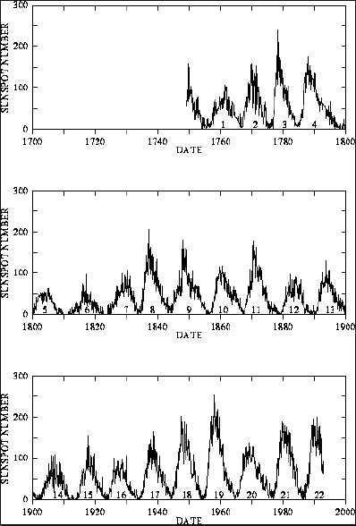
5. The sun has various overlapping cycles of increasing and decreasing magnetic activity. The level of magnetic activity can be measured by the number of sunspots that can be observed. From here: "Sunspots were observed in the Far East for over 2000 years, but examined more intensely in Europe after the invention of telescopes in the 17th century. In 1647 Johannes Hevelius (1611-87) in Danzig made drawings of the movements of sunspots eastwards and gradually towards the solar equator. In 1801 William Herschel (1738-1822) attempted to correlate the annual number of sunspots to the price of grain in London. The 11-year cycle of the number of sunspots was first demonstrated by Heinrich Schwabe (1789-1875) in 1843."
6. That's all simple enough so far. What is interesting is the converse: when there are more sunspots than usual, that means that the sun's magnetic activity or 'solar radiation' is stronger, which creates a solar wind, which deflects cosmic rays from the earth, so there is less low-level cloud formation, so temperatures rise, harvests improve etc.
7. The proof of the pudding is in the eating, of course. The sun's magnetic field seems to go through lots of different overlapping cycles, the shortest is an eleven-year cycle, but there are much longer ones - so at some points in time we'll be at the bottom of one cycle but at the top of another, so they would cancel out; at other times we'd be at the top or the bottom of two or more different cycles, so they would reinforce each other. If (and that's a big IF) people are clever enough to work out these cycles, and they do indeed have the effect that is assumed (another big IF), then they should be able to forecast climate change reasonably accurately.
Glossing over the almost tongue-in-cheek retraction at the start of this article..."Typically, sunspots flare up and settle down in cycles of about 11 years. In the last 50 years, we haven't been living in typical times: 'If you look back into the sun's past, you find that we live in a period of abnormally high solar activity,' Dr. Weiss states. These hyperactive periods do not last long, 'perhaps 50 to 100 years, then you get a crash ... It's a boom-bust system, and I would expect a crash soon.'"
Excellent! Something else to worry about.
Posted by
Mark Wadsworth
at
15:25
17
comments
Labels: Clouds, Global cooling, Science, The Sun